


Route type: Two-way
Difficulty: 1/5 (Easy)
Duration: 2h
Length: 6km
Equivalent length: 6 km
Ascent: 288m
Descent: 285m
Maximum altitude: 933m
Minimum altitude: 781m
Drinking water: Yes
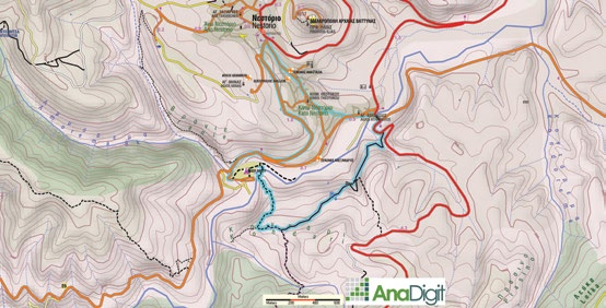
The circular route Nestorio–Kontari–River Party–Nestorio is an introductory journey through Nestorio’s immediate surroundings, initiating the visitor into the area’s basic elements.
From the road centre of Nestorio we descend to the Kotyli bridge, and after crossing a sturdy wooden bridge we enter a broad path heading west. We pass a stone-built fountain (dry) and arrive at the Kontari shoulder, a spot with a kiosk and fine views.

From here, a well-constructed descending path brings us to the River Party site (a large footbridge over the Aliakmonas, an organized area with rich recreation facilities).


We return to the starting point via the local asphalt roads.
Route walkability
Distribution over
altitudinal zones
Elevation profile
Starting – ending point and maximum elevation

Tips
- At the River Party site, food and recreation services operate for most of the year, while in mid-summer the River Party — famous throughout Greece — is organized, with concerts, events and various activities.
Remarks
- The route is well marked.