


Route type: Two-way
Difficulty: 1/5 (Easy)
Duration: 2h 45min
Length: 8,1km
Equivalent length: 8,1 km
Ascent: 581m
Descent: 440m
Maximum altitude: 1062m
Minimum altitude: 778m
Drinking water: No
The Vlahostrata of Gramos was, like the other livestock roads of the same name from the old days, a caravan route serving the arrival, supply, transactions and ultimately the departure of the large flocks of the Vlach and Sarakatsan semi-nomadic herders. A variation of the route leads to the Guerrillas’ Hospital.
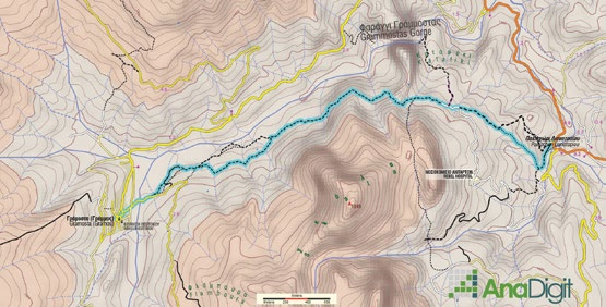
The route follows the only surviving section of the great flock highway known as the Vlahostrata. It starts from Lianotopi and ends at the village of Gramos, passing through the Portes, above the south cliff of the gorge of the Aliakmonas’ upper course.
This old strada is in places almost 2 metres wide with a steady cobbled surface, while in others it has degraded into a narrow dirt path.

About midway along the route, a good path with satisfactory marking leads to the large cave which, together with many surrounding structures, formed the Guerrillas’ Hospital.

The related arrangements are still discernible inside the cave.


After the Portes, where there is a stone shrine, the Vlahostrata runs through bright meadows as far as the great bridge of Gramosta and ends at the village.
Route walkability
Distribution over
altitudinal zones
Elevation profile
Starting – ending point and maximum elevation

Tips
- The route is well marked with a yellow square.
- After the first ascent we meet the forest road serving the DSE Hospital.
Remarks
- The fountain at Lianotopi has no water.