


Route type: Two-way
Difficulty: 3/5 (Medium difficulty)
Χρόνος πορείας: 8h 15min
Length: 12km
Equivalent length: 12km
Ascent: 1276m
Descent: 158m
Maximum altitude: 2519m
Minimum altitude: 1310m
Drinking water: Yes
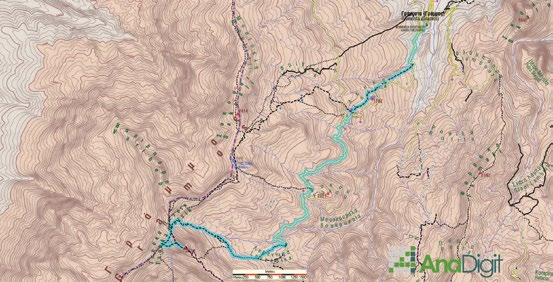
The most popular ascent to the highest peak of Gramos, Tsouka Petsik or “2520”, starts from Gramosta and passes through the Leventiko meadow. The route follows a series of smooth meadows up to the ridge, and from there climbs to the summit.
From the village of Gramos (or Gramosta), we take the agricultural road towards Lefka, continue on the left branch towards the Fakou meadow, and arrive at the Leventiko meadow, where there is a spring and two cement huts.

From Leventiko we will take the livestock trail that crosses the meadows at a relatively high level, avoiding the zone where the ravines have furrowed the terrain.

The trail is essentially the main road carved by the animals, and it constantly splits into branches which then rejoin. At first with a very gentle gradient, the trail reaches the base of the slopes below the 2520 summit, and there it begins to climb at a steady gradient with small switchbacks.

We finally reach the saddle between the 2520 summit and the unnamed 2414 m. From here, we will take the very good path southwards and, after 500 m, turn left towards the summit.

Route walkability
Distribution over
altitudinal zones
Elevation profile
Starting – ending point and maximum elevation

Tips
- Water can be found only at the spring between the huts at Leventiko. Note, however, that until the flocks come up, the waters of the large streams are crystal clear.
Comments
- The route is well marked with a red circle.