


Route type: Two-way
Difficulty: 2/5 (Medium difficulty)
Duration: 5h
Length: 11,5km
Equivalent length: 11,5km
Ascent: 1146m
Descent: 101m
Maximum altitude: 2444m
Minimum altitude: 1361m
Drinking water: Yes
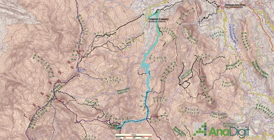
The route Gramos village–Kiafa saddle–Perifano is the easiest and most “scenic” ascent among the great summits of Gramos. The route runs through the great meadows of Gramosta as far as the Kiafa pass, and then continues through wilder terrain to the prominent cone of Perifano (2,444 m).
We start from the parish church of Gramosta and descend to the river, crossing it via a large road bridge. From here, for about 6.5 km, we will walk on or near the livestock road serving the village’s last sheepfold, at the foot of Kiafa.

The dirt road switchbacks on the slope. We reach the end of the road, at a small hollow with remains of a pen. A little above the fenced area there is a seasonal spring.

Here we will find the trace of the old path to Aetomilitsa. The path leads to the Kiafa pass, where there is also an old signpost base, which today serves as a bench.

Here we will leave the main path and move westwards, along the axis of the ridge, on a secondary but clearly visible path, quite well marked.

The path will pass smoothly below the crags of a small summit. On smoother terrain, we continue on the crest until we meet the old military lane from Gkesos towards Perifano.
On much easier terrain now, we continue on the lane to the highest point of the summit’s cone.
Route walkability
Distribution over
altitudinal zones
Elevation profile
Starting – ending point and maximum elevation

Tips
- The route is well marked.
- Water can be found only at the spring at the last sheepfold.
Comments
- On some sections of the route, a newer dirt road has “pressed down” / cut across the path.